1.6 million geographical datasets opened up
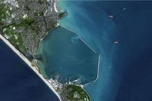
UK Vision-1 © Airbus DS 2019
Academics and students are to be given access to more than 1.6 million geographical datasets, including the most comprehensive index of maps ever brought together.
Jisc, the UK not-for-profit company which supports education and research technology, announced the launch of the improved Jisc Geospatial Data service, featuring the implementation of a new search tool, GeoSeer, and the access to Airbus’ Vision-1 satellite imagery.
The Jisc service brings open data and licensed data together in one interface – integrating GeoSeer, which can search for spatial data by location and subject. It also offers the opportunity to review multiple search results at once by overlaying any of the datasets to study and compare changes in the landscape over time.
Phil Brownnett, head of UK programmes at Airbus Defence and Space, Intelligence said: 'We are very pleased to have been working with Jisc to provide academics and students easy access to valuable datasets, especially Vision-1 high-resolution satellite data. We are committed to empowering researchers and this will help transform their geographical work.'
Early next year, Airbus’ Vision-1 satellite imagery will complete this dataset, allowing researchers to focus on specific locations across the world, with fine and up-to-date details. Jisc is looking to work with universities to explore how the GeoSeer tool and Vision-1 data can enhance research, teaching and learning.
Cam Swift, geospatial data service development manager at Jisc, said: 'We worked with Airbus to integrate GeoSeer into our service, bringing together over 1.6 million open source maps and licensed data into one easy to use interface. This will make it easier for students, academics and researchers to use geographical information. Users can log into one service bringing together open access and licensed geography data and working with them seamlessly.'
Jonathan Moules, founder of GeoSeer added: 'It's great to see all of this data made readily available to so many people. Freely available geographical data is really hard to find using conventional means and GeoSeer was developed to ameliorate that. Now thousands in academia have access to this data and can utilise it by simply typing in a search term and then add their desired search layers.'
For more information and how to subscribe contact help@jisc.ac.uk